Products Surveyor Scherbel, Ltd. provides:
Boundary Surveys
Drone, Total Station, & GPS
Drone, Total Station, & GPS

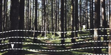
Determine property lines and define property corners
Drone, Total Station, & GPS
Drone, Total Station, & GPS
Drone, Total Station, & GPS

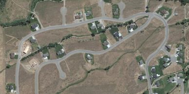
Collect topographic data and leverage areal photographic mapping with precise lot line overlays
Water Rights
Drone, Total Station, & GPS
Water Rights

Discover and verify your rights to a source of water
ALTA Surveys
Topographic Surveys
Topographic Surveys
Verify your property lines, improvements, easements and more
Topographic Surveys
Topographic Surveys
Topographic Surveys
Get site plans and topographic information for your land planning
Ownership Research
Construction Surveys
Construction Surveys
.jpg/:/cr=t:24.9%25,l:0%25,w:86.7%25,h:64.94%25/rs=w:388,h:194,cg:true,m)
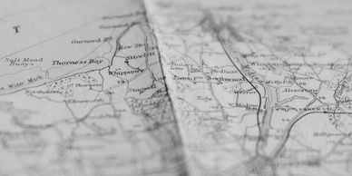
Trace the ownership history and mineral rights of your property
Construction Surveys
Construction Surveys
Construction Surveys
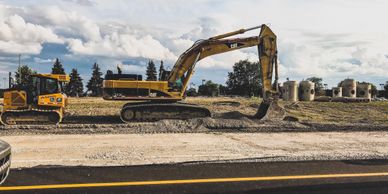
Locate improvements for a construction project
Expert Witness
Construction Surveys
Expert Witness

Surveyor Scherbel, Ltd. can act as expert witnesses in cases where litigation, of boundary and easement issues, is the last resort.
ALTA/NSPS Surveys

Commonly called an ALTA Survey, this boundary survey is acceptable to title insurance companies for purposes of insuring title to property free and clear of survey questions, except those disclosed by the ALTA survey and indicated on the plat. It is used for mortgages, title insurance, and real estate transactions. ALTA surveys adhere to very specific requirements set forth by the American Land Title Association (ALTA) and the National Society of Professional Surveyors (NSPS), and include, among other things, information on easements, property boundaries, improvements, and show access to property, zoning classification, etc.
Boundary Surveys
A survey made to establish or re-establish the lines of property boundaries, easements, or other land interests on the ground. Boundary surveys include creating a new parcel of land for transfer of title or interest by preparing accurate descriptions and plats of boundaries and easements.
Deliverable products of a boundary survey include monuments in the ground (to mark the position of property corners), a description of the property (to be used in deeds conveying title or other interest), and a map or plat of the property (recorded in the public land records).

Construction Surveys

A survey provided for a construction project to locate improvements to be made, such as structures, concrete curbing, asphalt paving, drainage, etc., with information to control vertical and horizontal alignment and dimensions of the proposed improvements.
Drone
Unmanned Aerial Vehicles (UAVs), or drones, are used to capture aerial data useful in preparation of boundary and topographic surveys. This aerial data is used to create accurate 2D and 3D maps of terrain and other features for land planning and accurate depiction of boundary lines over difficult terrain.

Expert Witness
With nearly 100 years of combined professional experience, the licensed Professional Land Surveyors of Surveyor Scherbel, Ltd. can act as expert witnesses in cases where litigation of boundary and easement issues is necessary as a last resort.
Ownership Research
Transfer of title from one owner to another is accomplished by preparing and recording a document called a deed. Each deed contains a description of the property and the rights associated with it, including easements, mineral and water rights, and other interests. Each survey includes research of land ownership records to create a chain of title to ensure accurate determination of boundary lines and identification of ownership interests for each property.

Subdivision Design and Land Development Consultation

Subdivision development is the process of creating lots, blocks, and streets according to an orderly and specific plan for the development of rural areas or in towns and cities.
Subdivisions are completed through a platting and approval process by local jurisdictions. Subdivisions usually require the developer to install utility improvements such as water, sewer, power, telephone, gas, drainage, roadways, etc.
Topographic Surveys and Site Plans
A survey of an area of land, which has as its major purpose the determination of the configuration of the surface of the ground and the location of natural and artificial objects, including utilities, drainage ways, structures and other related items. This survey is usually requested for use in engineering and architectural planning.

Water Rights
A consultation in laws and regulations pertaining to beneficial use of surface and ground water. A water right consultation includes research on easements for water distribution and use as well as the collection of field data to prepare appropriate permits and maps for adjudication of appurtenant water rights.